The other day I was looking at a world map. A ‘Mercator Map’, which is the nice rectangular map all of us are familiar with and which is still used in our school atlases to teach Geography.

There’s a wonderful free-to-access site, www.thetruesize.com, that lets you shift around countries on the Mercator Map and figure out the actual size of a country compared to other countries/continents. Do visit the site: it’s fun, and also a real eye-opener! Here are a few screenshots showing how big India actually is compared to Europe and Greenland, and how big Brazil is compared to India [all images captured from http://www.thetruesize.com]

India and Europe

Greenland and India
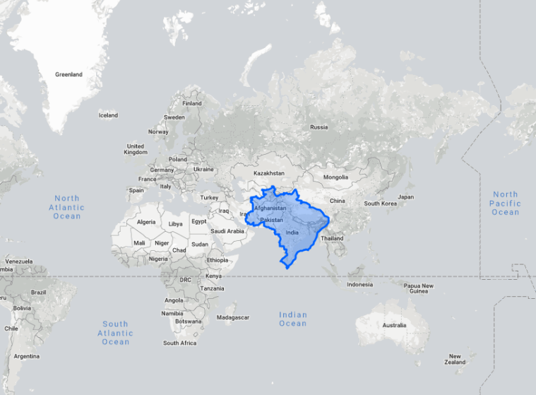
Brazil and India
Some say the European colonizers used the Mercator Map to boost the apparent sizes of their own countries and thereby belittle (literally!) their African and Asian colonies. That’s a matter of perception: but I don’t think we can really fault the man who created the Mercator Map in 1569 – geographer and cartographer Gerardus Mercator of Flanders (Belgium) – because his sole and very honourable aim was to make a map that would help voyagers from Europe navigate the oceans more easily.
Besides, as an Indian I personally believe we Indians are masters at belittling ourselves at the drop of a hat – or more accurately, at the slightest hint of ‘Western’ disapproval – and that we should cure ourselves of this low self-esteem rather than pretend that it is some kind of genetic disease impregnated in our Bharatiya DNA by Thomas B Macaulay.
Anyway, while playing around with the Map and reflecting on how easy it is for me – perhaps for all of us – to be misled by warped imagery and memory, by ignorance and illusion, by prejudice and propaganda, I remembered an article I’d written for the Indian Express over 15 years ago – written in deep angst because the media at that time seemed focused on whipping itself, and indeed the entire population of India, into a frenzy of self-flagellation following the hideous Gujarat violence of 2002.
Here’s the article: reading it again, I get the feeling nothing much has changed….good or bad.
What do you think? I’d love to know…
THE GOOD SHIP INDIA
Indian Express: Nov 27, 2003
[http://archive.indianexpress.com/oldStory/36064/]
At times of internal strife one sometimes wonders: will India ever be united? Open the atlas and look at Europe. Start at Ireland, and trace a path eastwards across the Irish Sea to England, and onwards across the Dover Straits through Belgium, the Netherlands, Germany and Poland. Turn southwards and wander through the Czech Republic, Slovakia and Hungary; wheel west into Austria, and again south to explore Slovenia, Croatia, Bosnia-Herzegovina, Kosovo, Serbia, Albania, Macedonia and Greece. Skim across the Adriatic Sea to travel through Italy, cross the Alps into Switzerland, cut eastwards to sweep across France, and then veer southwards over the Pyrenees into Spain, and finally, Portugal.
A long journey across a vast terrain, to be sure. Yet all those lands we traversed would together fit into the territory of India with room to spare. What’s more, India comprises people who differ from each other in far many more ways than the peoples of Europe: in race, religion, language, culture. To the wonderment of the world, the good ship India hangs together! Battered she is by violent storms of communalism and sectarianism, tossed to and fro by the conflicting pulls of her bewilderingly diverse populace, yet India sails on, her billion passengers united by a Vision.
A Vision, of a land in which all are equal and enjoy equal rights.
The Constitution of India, which we gave ourselves on 26 November 1949, describes this Vision in great detail. It crystallizes the most sublime ideas of millennia. It tells of a just and humane land, where we may dwell and think and speak and follow our chosen beliefs and faiths freely and without fear. The Constitution alone binds us together. It expresses our shared vision, and contains the blueprint for the ship that will help us realize that vision, the ship we have named the Sovereign Socialist Secular Democratic Republic of India.
The unity we seek is alive in the Constitution; in times of strife, internal and external, we must reaffirm our faith in this great Book. Amends must be made for past wrongs; walls of prejudice that have hardened over centuries must be dismantled not by force but with understanding. There will be upheavals and unrest; hurdles posed by the corrupt, the jealous and the slothful, by those who interpret freedom as mere licence. But as long as the Constitution and its vision are alive in our minds and our hearts, India shall prevail.
And her 5000 year-old voyage will continue.
